
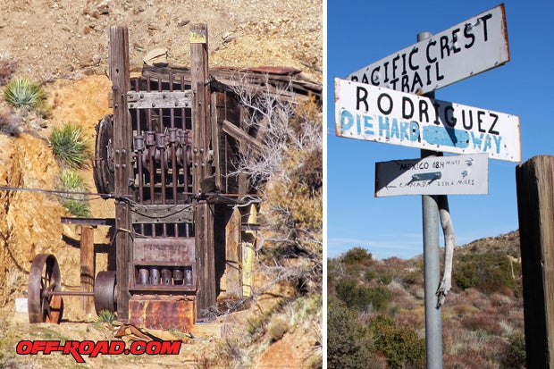
Josh Burns driving on Rodriguez Canyon, heading east towards Anza-Borrego. This route was used as a short-cut between the desert and mountain trails during the Gold Rush. The Guy Urquhart ranch was in Rodriguez Canyon and dates back to the 1920s. Some ruins remain, including a concrete bunker.
Located about 57 miles northeast of San Diego is the town of Julian, Calif. The historic mountain town is a favorite place to visit for San Diegans and is well known for its apple pastries, arts and crafts. Founded by Drue Bailey, and named in honor of his cousin Mike Julian, these Georgia boys settled a lush meadow between Volcan Mountain and the Cuyamacas where present day Julian is found.
So what does Julian have to do with off-road? Its location makes it an ideal jumping spot for exploration of the Cuyamaca Mountains, Anza-Borrego and Ocotillo Wells SVRA. It�s also a good place to pick up some local history and a slice of Julian apple pie.
SAN DIEGO GOLD RUSH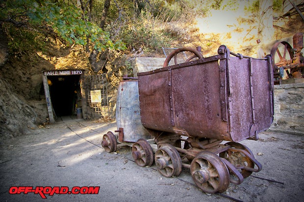
Following the American Civil War, the town of Julian experienced a gold rush. In 1869 a former slave named A.E. �Fred� Coleman found placer gold while crossing a creek near present day Julian. Others soon heard of Coleman�s finding and quickly set out to find the source. On February 22, 1870, the first hard rock mine was claimed. Since it was registered on President George Washington's Birthday, it was named in his honor. More mining claims followed, establishing the Julian Mining District. It was San Diego County's first and only gold rush.

Gold and quartz from the Julian Mining District are on display at the Wells Fargo Stagecoach Museum in Old Town San Diego State Park.
The Julian Gold Rush was short lived from about 1870 to 1880. As mining companies left the Julian Mining District, some people decided to stay and make a life in the San Diego backcountry.

Apple Orchards are located all around Julian. During the months of September and October many are open to the public for apple picking.
Miners turned farmers, and gold was replaced with apples. The climate of Julian made it ideal for the fruit tree, and to this day it is available for the pickings during the harvest months of September and October. From these delicious apples also come the famous Julian Apple Pies.

Apple treats, antiques and even real snow during wet winters.
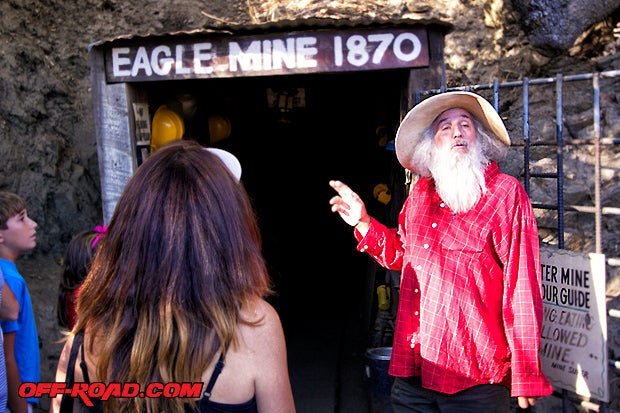
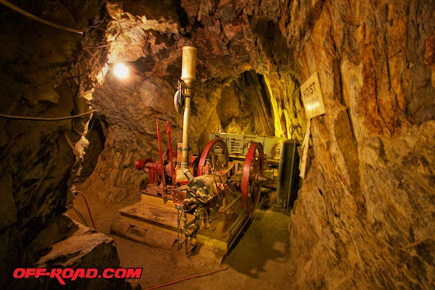
Apples aren�t the only good things left in Julian. Mining history is still alive at the Pioneer Museum and Julian Historical Society. For those looking to explore a real hard rock mine, the Eagle & High Peak Mines are near and offer tours seven days a week.
Less than a mile away from the Eagle & High Peak Mines is the Washington Mine. Thanks to the Julian Historical Society, the Washington Mine and a good-sized display of mining machinery is available for the public to visit. Although the entry to the actual mine is not possible, it is still significant since it was the first mine in Julian.
A number of shops line Main Street, and Julian becomes a happening place on the weekend. For those looking for a slower-paced experience, come during the week.
A good place to start your tour of Julian is at the Pioneer Museum. A large collection of Julian mining history can be found under this roof�including mining tools, old photos, carriages, art, and colorful stories of the people that helped Julian grow.

Many of the buildings in Julian date back to the late 1800s and can quickly transport one�s imagination to simpler times. The Julian Pioneer Museum is a great example.
TRAILS Shane and his Bronco exploring trails outside of Julian, CA.
Let�s not forget about the trails�they�re everywhere! From old overland stagecoach routes to abandoned toll roads, there is plenty to see and do where the pavement hits the dirt. Julian can be accessed from San Diego via HWY 67 or HWY 78. The two-lane country road follows a historic wagon route from Ramona to Julian. The drive is twisty and travels through some scenic, wide-open spaces, ranches and farms. It�s quite beautiful in the Fall and Spring, with rolling green hills and Oak Trees in every direction.

Traveling North on Black Canyon Road from Ramona toward Julian can be done on dirt. Traveling along the edge of the Cuyamaca Mountains, the route runs parallel to HWY 78 and meets up in Santa Ysabel.
If you have time and are feeling adventurous, Black Canyon Road, which is a windy dirt road, travels parallel to HWY 78 from Ramona and re-connects in Santa Ysabel near the foot of mountain before climbing up to Julian on HWY 78.
From Julian, one can access trails leading into Anza-Borrego State Park at Banner--about 10 miles east on HWY 78. Across from the Banner store is the trailhead for the Chariot/Oriflamme Canyon Trial. The 11-mile one-way trail travels through areas heavily mined during the Julian-Banner Gold Rush.
The Oriflamme trail is moderate with mildly rocky, steep climbs. For a complete loop, Rodriguez Canyon can be taken back to Banner. If one heads east on Oriflamme Canyon trail it connects with County Road S2 in Anza-Borrego State Park.
Anza-Borrego State Park related stories:
Off-Road Travel: Anza-Borrego State Park � North
Off-Road Travel: Anza-Borrego South
Up until recently, Rodriguez Canyon was actually rated a difficult trail. Recent fires in that region required some road leveling to allow fire engines into the remote canyon area. In the process, the difficulty of the trail has also been downgraded to easy.

Rodriguez Canyon Trail in 2010 before fire grading took place.
Perhaps in a few years it will return to a moderate-rated trail. In any case, it�s still worth checking out. Rodriguez Canyon intersects the famous Pacific Crest Trail, which can be hiked from Mexico to Canada. Also along Rodriguez Canyon is the Ranchita Mine. It is on private property, but a five-stamp mill and boiler can be seen from the side of the road.
CUYAMACA RANCHO STATE PARK
If time is available, a short drive to Cuyamaca Rancho State Park is recommended. Located about 7 miles south from Julian is the site of the Stonewall Mine and Mill. This was the highest producing mine during the Julian Gold Rush, producing over $1 Million in gold.
.")
Stonewall Mine - Cuyamaca Rancho State Park (Photo: California State Parks).
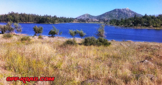
Also in the park is Lake Cuyamaca, a year-round fishing lake stocked with trout and beautiful views. The park's 26,000 acres feature many trails open to hiking, horseback, mountain biking and camping.
Next time you�re driving out to the desert, or simply want a quick escape from the Concrete Jungle, give Julian a try�just don�t forget to save room for Apple Pie.
RESOURCES

We highly recommend the following guidebooks for planning and referencing trails and important landmarks in Anza-Borrego:
The Anza-Borrego Desert Region, by Lowell & Diana Lindsay
Guide to Southern California Backroads & 4-Wheel Drive Trails, by Charles A Wells
California Desert Byways, by Tony Huegel
A Good Camp - Gold Mines of Julian & Cuyamacas by Leland Fetzer
SOURCES
Julian Chamber of Commerce
http://www.julianca.com/
Anza-Borrego State Park
http://www.parks.ca.gov/?page_id=638
Cuyamaca Rancho State Park
http://www.parks.ca.gov/?page_id=667
GPS COORDINATES
Julian, CA
N 33.0786402, W -116.6019847
Washington Mine
N 33.08254 W -116.60057
Eagle & High Peak Mine
N 33.08116 W -116.59752
Stonewall Mine
N 32.98282 W -116.56919
Banner, CA (Trailhead for Chariot/Oriflamme Canyon Trail & Rodriguez Canyon)
N 33.0675 W -116.5476
|
Off-Road.com Newsletter Join our Weekly Newsletter to get the latest off-road news, reviews, events, and alerts! |
Follow @Off-Road
 Your Privacy Choices