| On January 14, 2000, two of us Lake Arrowhead 4WD Rock
Crawler members decided to make a trip up to Big Bear, California, in search of
some challenging rock crawling. If you're not familiar with this area, I have
provided a road map at the bottom of this page. The map ranges from Palm Springs
to San Diego, and should you help find your way up to Big Bear.
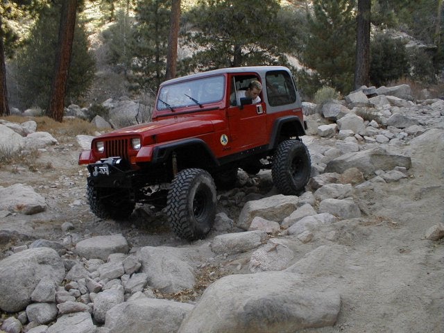
NOTE: Before you decide to make this trip, keep in mind that an Adventure Pass is required for use of forestry land. I know what you're thinking, "What, is he serious?" Sorry to say, Yes I am. Although I don't agree with the need for an Adventure Pass, we still have to obey the rules and regulations. These passes can be purchased at the local forestry stations and only cost a minimal amount (approx. $10 a day, I think). We took Hwy 18 all the way up to Big Bear City. Here, we stopped at a local gas station for fuel and we packed a lunch. Then, we continued to a nearby forestry station just outside of town on Hwy 18. After taking a brief look at some trail maps and asking a Ranger a couple of questions, we were on our way. The trail started in a small town called Fawnskin, just outside of Big Bear City. This trail is a little tricky to find, tucked away at the end of a poorly marked road. Sure enough, we found the trail. We continued on the trail for a while, then turned off in a turn out area. This gave us an opportunity to air down, release sway bar disco's and plan a route on the map. Although the maps weren't as detailed as we would have liked, they still gave a basic trail description. We regret not getting a detailed map from www.sidekickoffroad.com/maps.htm but we made do with what we had. This trip is Part-1 of our Big Bear expeditions. We will continue to explore new trails and keep you posted. Our Big Bear adventure was about to begin. We entered trail #3N14 in Fawnskin. The first couple miles of this trail are really easy, as is clearly stated on the map. In an area known as Hanna Flats, the trail splits off in two directions. One continues on trail #3N14 and doesn't seem to be too difficult: the other splits off on to trail #3N93, which according to the map is rated "black diamond". Of course we decided to take trail #3N93. This is where the fun began. We crossed the creek, which luckily wasn't too deep on this trip.  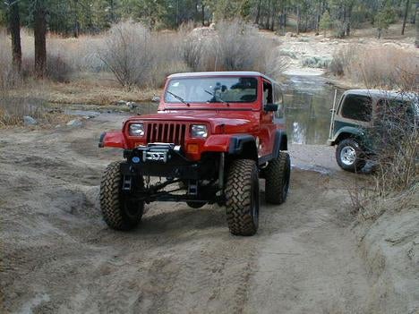 From here the trail split into several paths, which lead to the same trail. Each path had hills of all difficulty levels. We chose the most difficult line and headed up the little hill. The two to four feet deep ruts and slippery tires made for some slick wheeling. Surprisingly, I didn't spin a tire once, not even when the front tire came off the ground a couple feet. My new Detroit soft locker recently installed at Hicks (www.Hicks4x4.com ) helped a lot. My newly installed rear differential is a Ford 8.8 thanks to its donor vehicle, a '98 Ford Explorer, and is equipped with 4.10 gears. After playing in the ruts and a little 3-wheel action, we knew this trail was going to be fun.    Around every corner arose a new obstacle and challenge. We met two guys on dirt bikes that decided to follow us and watch a little 4-wheeling action. I figured we'd be doing most of the entertaining, but to my surprise they put on a show themselves. The ice and snow still on the trail made for some good crashes, and trust me they didn't disappoint....hehehe. At the end of trail #3N93 there was a nice rock garden, approximately 100 feet long. With boulders the size of washing machines, it made for some good rock crawling. (These pictures don't justify the difficulty). 


Though not causing too much damage my vehicle, I bottomed out my rear diff once but had no problems. Alex also high centered Mr. "rear Dana 44" on the same rock section. Nothing major, just a few scars. We later discovered that he hit the rear diff cover a little harder than we thought. After a closer look, we realized his cover was dented in about 1" and about the diameter of a golf ball. Luckily, this didn't cause any damage to the gears inside, but a few weeks after the trip, he replaced the cover. Alex's TJ is now sporting a chrome diff cover, and he's planning on getting a rear diff cover from FourXdoctors (www.FourXDoctor.com). 
 From here, we continued on about a mile down the trail until we came upon another water crossing. It was just a little stream and wasn't much more than a foot deep. We continued on trail #3N16 which on the map was clearly marked an intermediate trail. With our goal of finding challenging terrain, we headed on to Crab Flats. Here, we found some moderately difficult rock and rut sections, but still nothing challenging. Towards the end of the trail, we came upon another rock garden which was pretty long and seemed to offer some challenging terrain. The garden had easy sections and really difficult sections for us to take. Of course, I had to take the most difficult area and still didn't have any problems and didn't spin a tire. I guess my rig was plenty equipped for anything Big Bear's trails could throw at me. Towards the end of this trail is a popular local obstacle known as "Ball-Buster". Here's a picture of Alex getting a little 3-wheel action at the bottom of Ball-Buster.  This trail can become extremely difficult and rutted, depending on the season and weather. We followed the trail down to a popular off-road area, known as Deep Creek. Fortunately, the creek wasn't very deep this time, approximately 2 to 2-1/2 feet deep. This creek can get very deep and powerful depending on the time of year. The trail is sponsored by the "DIRT DEVILS. " ( http://www.dirtdevils.org/) After crossing Deep Creek,  there are a few mild rock sections here and there for about the next mile. After rock crawling the trail through Big Bear, this trail didn't even compare. Two wheel drive is fine for these roads. From here, the trail splits into two directions, one leading to more San Bernardino Mountains trails, with endless possibilities like places called Devil's Hole, The Pinnacles and Silverwood Lake. The other trail leads out to a nearby town called Cedar Glen, approximately three miles away. We decided that after rock crawling for six or seven hours, we had enough for one day, and decided to finish the trip and head towards Cedar Glen. We took Trail #2N26Y up to a paved road called Hook Creek Rd. This road goes for about two miles on into town, where there is a 76 Gas station and a couple of cafe's and restaurants. Surprisingly, we only used about a quarter tank of gas each, so we decided to head home without fueling up. This summer, our club - The Lake Arrowhead 4WD Rock Crawlers, plans on taking several more trips to explore all the trails Big Bear, California has to offer. Keep a look out for continued articles. Note:
Part 1 of Exploring Big Bear was an enjoyable trip but took
approximately seven hours of continuous crawling to complete in one day. We were
unaware of the length and would highly recommend you make this a 2-day trip.
There are nice campgrounds at Crab Flats that you might want to consider.
Vehicle Requirements:
BIG BEAR TRAIL
MAPS
Provided by San
Bernardino County Forest Service
(Click on Pictures for Large
printable size)
|


|
Off-Road.com Newsletter Join our Weekly Newsletter to get the latest off-road news, reviews, events, and alerts! |
Follow @Off-Road
 Your Privacy Choices